Showing posts with label mountain history. Show all posts

Friday, 13 March 2015

The Grand Route Forbes — a long-distance hike in the Alps


Regular followers of this blog will be aware that I admire the writings of James Forbes, a Scottish geologist best known for his pioneering studies on the glaciers of the Alps. I have written before about the long foot journey he conducted in 1842, and I've even followed the central portion of this route myself.

It turns out that his wanderings of 1842 can be adapted into a truly superb long-distance Alpine trail.

I've been picking at the idea for a couple of years. While reading his book, I plotted the approximate route on the map Forbes used to explore the Alps (a variation on Keller's map, which is very inaccurate). I have not yet plotted all of the route on modern maps to any degree of detail, but I've seen enough to realise that this is potentially one of the best long-distance hiking routes in this part of the Alps.

Forbes's wanderings, plotted on his map of 1842.
Adapting the original route

It's important to realise that Forbes was a nomadic scientist, not a backpacker. Consequently his journey was planned with certain specific objectives in mind, and also the practicalities of travel at a time before the Alps were developed for tourism. He mainly stayed in inns and friendly houses, so sometimes he was forced to make detours towards centres of population. He covered the same ground more than once on several occasions and made one particularly lengthy out-and-back detour to the Great St Bernard Pass.

There's also technical difficulty to consider, and the fact that the glaciers of the Alps have changed considerably since 1842. For example, the traverse of the Col du Geant and Mer de Glace from Courmayeur to Chamonix is a very different proposition in the early 21st century. Following this section of his route would require covering most of the Tour du Mont Blanc twice.

View from Prayayer Alp, above the Valpelline
It's therefore necessary to adapt Forbes's 1842 route if we want to turn it into a modern trail. The purpose of a journey like this today would, after all, be to enjoy a beautiful long walk in the Alps — it would certainly not be to slavishly copy a historical journey, although I believe there is much enjoyment to be had in emulating Forbes's voyage in spirit.

The modern Grand Route Forbes

My adapted "Grand Route Forbes" follows the majority of the original route, with a couple of omissions and modifications. I believe it takes the traveller through some of the finest landscapes in the Alps. Here's a quick mockup on a Google Maps screenshot:


The first portion of the voyage follows the Tour du Mont Blanc from Chamonix to Courmayeur, then up Val Ferret. Instead of heading back towards Chamonix, it passes through Orsieres and enters the Val de Bagnes, crossing the Fenêtre de Durand to Valpelline. The walker then follows the length of Valpelline before crossing the Col Collon and Arolla Glacier to Evolene. From Evolene — which makes a natural midpoint of the route — the glacier pass over the Col d'Herens takes the traveller to Zermatt (this is the most difficult section, and the only leg that will certainly require full glacier travel gear and the experience to use it).

From Zermatt, the hiker then embarks upon a variation of the Tour of Monte Rosa — a superb high-level route circumnavigating that great mountain massif via a number of high cols, and visiting several tributary valleys of the Valle d'Aosta. I have modified this portion of the route to avoid a needless diversion to the village of Chamois. The Theodul Glacier pass takes the walker from Zermatt to Champoluc, Gressoney, Alagna, Macugnaga, and over the Monte Moro pass to Saas Grund. Finally, the stunning Balfrin Höhenweg conveys you along the length of the Saastal to Stalden and finally Visp, where Forbes concluded his journey.

Distance, timings, and practicalities

Oyace, in the Valpelline. Beautiful walking country!
I have not calculated the full length of the Grand Route Forbes, but I estimate it — very roughly — to be between three and four hundred miles. Although it crosses many wild and high cols, it also visits numerous centres of population and is almost certainly possible to complete without having to wild camp or sleep rough, if that's the hike you want to hike. The voyage can be broadly viewed as a variation on three existing long-distance paths: the Tour du Mont Blanc, part of the Haute Route, and the Tour of Monte Rosa. There are numerous facilities along the way. If you have the money to spend, you can probably stay in mountain huts or hotels most nights.

This is not a mountaineering expedition, but some of the cols are high and glaciated. Notably, the route crosses the Col Collon, Col d'Herens, and Theodul Glacier. The first and last of these are not difficult and might be passable without glacier equipment by experienced walkers in good conditions, but the Col d'Herens is a technical, crevassed portion and it would be highly unwise to cross this without a rope and the necessary equipment. Walkers without a background in alpinism will probably need to hire a guide for this section.

The majority of the other cols along the way are below 3,000m, and during the summer season should be passable with standard walking gear. However, weather in the Alps can be fickle and it can snow any day of the year at these altitudes, turning an easy path into a much more difficult proposition. It's also likely that snow will lie on many of the higher areas well into July. The Tour du Mont Blanc, which largely forms the first portion of the route, can be viewed as a gentle introduction to the more difficult sections beyond. This is not a route for a novice walker.

My Grand Route Forbes journey


Mont Brule, from the Col Collon pass to Arolla.
I don't have a month or two to thru-hike the route in its entirety, but I have already walked the central section (Valpelline — Evolene) and intend to complete the entire route in instalments over the next few years. I relish the challenge of taking on my next planned section in September: the Tour of Monte Rosa.

It's a real pleasure to follow in the footsteps of one of my heroes from the history of Alpine exploration, seeing the same sights that Forbes saw, and reading his beautiful descriptions. When I hiked the Valpelline — Evolene section last year, I found the comparison between the landscape in 1842 and the modern era extremely interesting. It really hit home just how much the Alps have changed since then. The glaciers are, sadly, mere shadows of what they once were.

When I walk each section of the Grand Route, I will do so with Forbes's book in hand and my eyes open, trying to see the Alps as he saw them — and recording my thoughts on the changes that have taken place. It's going to be an incredible adventure, and if it takes me years to do it then it will be even more worthwhile in the end.

I am keen to hear from walkers who have already completed this route, or maybe even decide they would like to try it for themselves after reading this introduction. Please get in touch!

Saturday, 24 January 2015

Illustrations from after the Alpine golden age


Today I'd like to share some beautiful illustrations with you. One of my most prized books is the Badminton Book of Mountaineering, a massive tome of 19th century climbing lore compiled by C.T. Dent and published in 1892. It features contributions from the greatest climbers of the post-golden age era, including W.M. Conway, D.W. Freshfield, C.E. Mathews, and C. Pilkington.

This book isn't unique. It's one of a number of guides that aim to be complete mountaineering manuals — the most famous is probably Mountain Craft by G.W. Young — but what sets Badminton apart is the charm and humour of the illustrations. The captions are frequently witty (or not so witty) puns. There's a real sense that mountaineering is starting to find itself again as the 19th century draws to a close. After the 1865 Matterhorn disaster, and the first ascents of all the 4000m peaks were completed, Alpinism experienced something of a lull — but it didn't take too many years for a new generation to burst upon the scene with enthusiasm and new ideas.

Badminton is also notable for being the book that Aleister Crowley used to teach himself climbing.

This book has been absolutely key in shaping my knowledge of Alpinism in the 19th century, and was one of the most important sources of inspiration for The Only Genuine Jones and Crowley's Rival. I'll let the pictures speak for themselves. (Click for a larger version.)


This is the only photograph in the entire book.


Friday, 12 December 2014

The camera of the Abraham brothers returns to the Lakeland crags


Readers of my historical novel The Only Genuine Jones will be familiar with the brothers George and Ashley Abraham: climbing photographers from Keswick in the Lake District who teamed up with O.G. Jones to document many of his pioneering first ascents in the late 19th century. In my short story Crowley's Rival, Jones borrows a camera from the Abrahams' photographic studio and gets into difficulties while trying to descend a gully on Great Gable in the company of a young Aleister Crowley. This was a true incident documented from both sides of the dispute. In fact, it's arguable that the bulky camera tripod that made Jones so clumsy on the descent was partially responsible for the rivalry between Jones and Crowley, both in reality and my fictional narrative.

I was delighted to find out that one of the cameras formerly owned by the Abraham brothers has been loaned to the Mountain Heritage Trust, and currently resides in the Keswick Museum along with selected images from the Abrahams' collection.


This particular camera is an Underwood Instanto, manufactured by the E & T Underwood Company in Birmingham. This model was produced from around 1886 to 1905 and is made from mahogany and brass, with leather bellows. Although the Instanto was made in quarter plate, half plate and whole plate sizes, this specimen takes 10x12 inch plates. It's a gorgeous machine — but extremely bulky, which as we shall see is an important consideration for mountain use. The Instanto camera was sold for between £2 4s 6d and £6 2s when new.

The owner of the camera, who has loaned it to the MHT, is keen for it to be used once again in a mountain environment. On the 20th of April 2014 it returned to the crags of Scafell to take part in the centenary anniversary of the first ascent of The Great Flake climb on Central Buttress, which was one of the greatest pre-war rock climbs of the Lake District.

Professional photographer Henry Iddon is currently working on a fascinating project involving this camera. He intends to use the Instanto to record contemporary rock climbing images, in much the same way that the Abraham brothers used it to document the leading climbers of their era. I think anyone with an interest in either photography or mountaineering will agree that this is remarkable. Will a modern digital camera from the year 2014 still be operational a century from now? I very much doubt it.

Central Buttress, Scafell. This is a contemporary image captured
with the Instanto camera.
On a personal level, I find it extraordinary that a camera used by characters who feature in my works of fiction — and, indeed, it may even be the camera from Crowley's Rival — is still being used today. Projects like this make me very aware of both my privilege and responsibility in writing about these people and events.

I got in touch with Henry Iddon and asked him a few questions about the Instanto project.

1. Using a 19th century camera in the mountains must be dramatically different to using a modern DSLR, or even a more traditional film camera. What has the experience taught you about the skills and techniques of the pioneering mountain photographers?

Using the 10x12 is similar to using my 5x4 which I've been shooting "A Place to Go" on. Obviously the size makes it very cumbersome and you need a lot of space to operate it — loading a film into the dark slides is a performance as it needs a room, not a changing bag!

Everything has to be planned and worked through a process. Back then they used pre-prepared glass plates — we're using custom-made Ilford FP4 film which I source when Ilford do a bespoke service for unusual film sizes once a year, usually in August. Twenty-five sheets cost in the region of £160. We've also worked closely with Pete Guest at Image Darkroom in London.

After some trial and error we now know the process time for the film that gives a good negative. Because the camera has no shutter — exposure is by taking the lens cap on and off — and as we're using modern emulsion we're relying on processing and the exposure latitude of the emulsion to get a good exposure.

The Fell & Rock Climbing Club
2. What are the main challenges in using such a bulky camera in the mountain environment?

As with any large format camera in an outdoor environment the big issue is wind. The camera, and particularly the bellows, act like a sail — and movement or vibration would result in a blurred image — so it is only feasible to use it on still days. It also takes a while to set up. Being literally a museum piece we have to handle it with care.

As there is no tripod fitting we've had a table made for it to sit in with straps across. This table has a film camera tripod bracket attached to it so we can use a hefty tripod designed for a pro video camera. It's remarkable to think that the American photographer Carleton Watkins shot the US landscape, including Yosemite, in the 1860s using a camera taking 18x22-inch plates. And in 1875 another American photographer, William Henry Jackson, astounded the photography world by packing a 20x24-inch plate camera into the Rocky Mountains.

3. What can you tell me about your future plans for this project?

The camera is now in the Keswick Museum until May 2015 as part of the Mountain Heritage Trust exhibition. The plan is to use the camera to photograph some notable climbing achievements of the present day along with some contemporary mountain landscapes. So a camera owned by those who were, in many ways, the first action sports photographers and used 100 years ago will be returning to active service and record the leading lights of now. At the same time we'll be contrasting it with the latest technologies such as the DJI Phantom drones.

James McHaffie climbing on Reecastle Crag
Many thanks to Henry for these fascinating details of the photographic project — and don't forget, if you want to see the Instanto camera yourself it is on display at the Keswick Museum until May.

All images © Henry Iddon — All Rights Reserved.

Further reading

"Climbing into War, a Justified Art" by Claire Carter: article on Siegried Herford and the first ascent of the Central Buttress

Thursday, 31 July 2014

One hundred and fifty years

Image from http://1865.chamonix.fr/En/
Next year, in July 2015, the Chamonix valley will begin a series of celebrations marking 150 years since 1865, and paying tribute to one of the most remarkable periods in modern history: the Golden Age of Alpinism.

During this period, which lasted from roughly 1854 to the 14th of July, 1865, the Alps were thoroughly explored by sportsmen for the first time. Before the mid 1850s, people climbed for pleasure in the Alps, but the focus of attention was firmly on Mont Blanc and the majority of ascents were still being made for scientific reasons. That changed, however, when a new wave of leisured travellers (many from Britain) began scaling unclimbed Alpine peaks purely for the adventure.

Fifty-eight first ascents were made in the Alps between 1854 and 1865. Facilities in most Alpine valleys were still spartan. Climbing equipment was extremely rudimentary, consisting of nailed boots, hawser-laid rope, and long ice axes used to hew steps in the ice. Despite this, there were few serious accidents — until the 14th of July 1865.

On that fateful day, Edward Whymper and his companions finally made the first ascent of the Matterhorn after a determined campaign lasting many years with many failed attempts. The expedition famously ended in tragedy and cast a gloomy cloud over the sport of mountaineering for a long time afterwards. It marked the end of the carefree, joyous years of Alpinism.

Chamonix has always been the international centre of mountaineering, and it sounds like the celebrations will be something special to behold. Exhibitions, conferences, readings, performances, and much more are scheduled for July 2015. It appears that a retro ascent of Aiguille Verte is also being planned!

Monday, 7 July 2014

Aosta to Evolene - an Alpine journey in the footsteps of Professor Forbes


In 1842, Professor James Forbes undertook an epic voyage throughout the Alps. In 2014, I replicated a 40 mile portion of that voyage: the segment between Aosta in Italy and Evolene in the Valais. In this blog post I'd like to tell you about my adventure and what I have learned about the dramatic changes to the ice world in the last 162 years.

For those of you who might not be aware, Forbes is a main character in my Alpine Dawn series (beginning with book 1, The Atholl Expedition). In real life he was a prolific mountaineer, explorer, and geologist. In his many visits to the Alps he conducted pioneering work on the physics of glaciers and also helped to explore and map the higher regions of the Alps, particularly in the old territory of Savoy.

One reason I wanted to replicate this particular section of the journey was that it crosses the Col Collon, a high glacial pass between Italy and Switzerland. The section in Forbes' book regarding this pass is one of the most memorable; at the time of his crossing he believed he was the first explorer to navigate it, although evidence suggests it had been in frequent use by locals for hundreds of years.

Here's an overview map of my route.


Valpelline

My journey began on the 29th of June in the Italian city of Aosta. I hiked uphill for a few hours to reach the village of Valpelline, my first campsite and the true beginning of my journey. In 1842 Forbes found it to be a tiny settlement with no prospect of accommodation, but managed to secure a room in a friendly household. At that time travellers visited the area extremely rarely and Forbes commented that most of the settlements in the valley were badly afflicted by goitre and cretinism (common afflictions in the high Alps at that time).

The next morning I began the long walk to Prarayer. Most of the route is actually road walking these days but the scenery was so spectacular I hardly minded. The total ascent on my first full day was about 1,200m, and I passed through a number of small villages including Oyace (at a steepening in the valley) and Bionaz. The weather was sunny and very hot, the scenery rather more Italian than quintessentially Alpine.

Typical Val Pelline terrain. The village centre frame is Oyace.
At this point mountains of considerable height hugged the valley on both sides, but no glaciers were in evidence and little snow. Forests of larch and pine predominated, and the communities were generally agricultural and deeply traditional. In 1842 Italy as we know it today did not exist; this region belonged to the territory of Piedmont, part of the Kingdom of Sardinia.

Bionaz

Forbes writes:
The village of Biona is the last of any size in the valley,— the last, I think, which has a church. We halted there, and made a hearty meal in the open air upon fresh eggs and good Aostan wine. The village of Biona is 5315 feet above the sea, by M. Studer's observation.
Bionaz remains a tiny hamlet clinging to the edge of a precipice, and indeed it hardly seems to have changed in the last 162 years. It had a peculiarity in the 19th century: virtually all of the male inhabitants were also named "Biona," and that was the name of the guide Forbes engaged there to take them over the Col Collon into Switzerland. They nicknamed him l'habit rouge due to his habit of wearing scarlet clothes at all times, which was apparently a common trait in the Pays d'Aoste at that time.

Bionaz
Prarayer

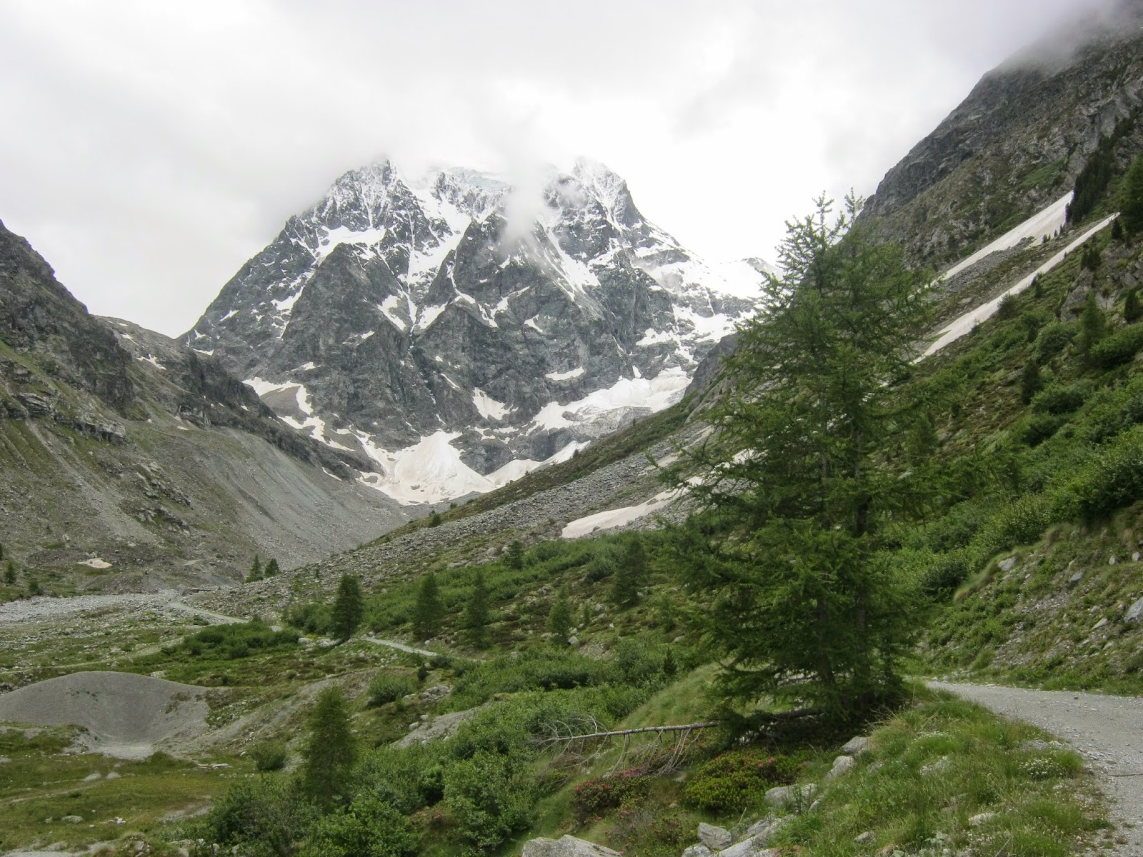
About an hour after Bionaz I reached the reservoir of the Lac des Places de Moulin, the waters of which are held back by an enormous dam. For the first time I gained a view of some of the 4000m mountains, notably Dent d'Herens, which rose as the highest point of a jagged chain above a glacier.

Forbes and his companions stayed at the "Chalets of Prarayon," today a hut known as the Rifugio Prarayer. However, since the formation of the reservoir has obliterated the old road, necessitating a path slightly higher up the hill, I selected a campsite at a flat alp above a larch wood. It had excellent views of the nearby mountains and was a peaceful place to stop for the night.

Camp one. Quite a view!
Alpenglow on the Dent d'Herens and satellite peaks
The Comba d'Oren

My third day was rather short as I wanted to spend as much time as possible exploring the Comba d'Oren. This is a deep valley leading from Italy to the Col Collon and the border of Switzerland. In 1842 it was reported to be substantially occupied by a glacier:
It was an hour's walk to the commencement of the glacier, which fills the top of the valley, and which descends directly from the great chain. Having gained an eminence on the south-east side of the valley which commanded the glacier, I saw that the ascent of it must be in some places very steep, though, I should think, not wholly impracticable.
And:
We there find a deep gorge, completely glacier-bound at its upper end...
 It's also interesting to note that, although the Comba d' Oren is only a few hours' walk from Valpelline and a day's ride from the city of Aosta (in 19th century terms), the region was almost completely unknown to explorers:
All our maps were here at fault ... no kind of resemblance to the outlines even of the great chain, and the passage must have been put down at random.
The Comba d'Oren
Today the Glacier d'Oren, which Forbes and his companions followed to the Col Collon, is dead. Only semi-permanent snow patches remain, and the other two glaciers in the valley have dramatically retreated. I think it very probable that in 1842 there was only one much greater glacier here.

In 2014 the ascent to the Col Collon travels over a variety of scree slopes and small snow fields. It's astonishing to think that in a mere 162 years what was once a large glacier has completely disappeared.

The dead Glacier d'Oren. You can see the stubs of the Glaciers d'Oren Sud (left) and Nord (right) in the background.
A night on the glacier

I reached the Col Collon (3069m) early in the afternoon and made my camp. The snow was fairly soft so I took my time digging out and consolidating a tent platform. This was actually my first experience of camping on snow with a tent!

Camp Two, beneath the desolate cliffs of La Vierge.
It was a wild location. L'Eveque (3716m) towers above, spitting rocks down its central colour every now and again. The Cairngorm-like expanse of Mont Brule (3578m) looked a bit more friendly, and my original plan was to get up before dawn the next morning and make an attempt on that mountain.

Mont Brule
However, the weather soon took a bad turn, and by late afternoon I was starting to wonder if camping on the col had been a wise idea after all.

Bad weather coming in from Italy
I made the decision to stay the night. The only reasonable alternative would have been to descend towards Arolla, but with an entire glacier to traverse I didn't fancy my chances of finding a better campsite before dark.

A spooky descent of the Haut Glacier d'Arolla

When I woke at 3am, I looked out of the tent and saw that the clag had come in fast, so I went straight back to sleep, not waking again until 7. However, between 3 and 7 quite a lot of snow fell (about 6 inches altogether) and when I awoke the second time my tent was almost buried in it. Visibility had reduced to about twenty feet.

After digging the tent out
Alone on a glacier at over 3000m and in dreadful conditions, I knew I had to get out of there pretty quickly! I struck camp in ten minutes flat and began the descent to the Haut Glacier d'Arolla in poor visibility. The fresh snow also made the going treacherous, balling up under my feet, but crampons were necessary due to the patches of bare ice on the slope.

A rare view through a break in the cloud
Fortunately, the Haut Glacier d'Arolla is an easy glacier, relatively flat for the most part and with no real crevasses to worry about. The navigation was no more challenging than a day out in the Cairngorms, and once I focused on my situation and started using the map and compass, the descent proved to be straightforward.

The upper basin

In 1842, Forbes and his companions found the corpses of no less than three people on or near the Col Collon, attesting to its popularity at the time amongst traders and (often) smugglers. The sight of the second skeleton particularly affected the guide Biona, who refused to return that way home by himself after that leg of the voyage:
The effect upon us all was electric ; and had not the sun shone forth in its full glory, and the very wilderness of eternal snow seemed gladdened under the serenity of such a summer's day as is rare at these heights, we should certainly have felt a deeper thrill, arising from the sense of personal danger. As it was, when we had recovered our first surprise ... we turned and surveyed, with a stronger sense of sublimity than before, the desolation by which we were surrounded, and became still more sensible of our isolation from human dwellings, human help, and human sympathy, — our loneliness with nature, and as it were, the more immediate presence of God. Our guide and attendants felt it as deeply as we. At such moments all refinements of sentiment are forgotten, religion or superstition may tinge the reflections of one or another, but, at the bottom, all think and feel alike. We are men, and we stand in the chamber of death.
Philosophising aside, the thing that truly struck me was the contemporary description of the Arolla glacier:
The glacier on which we now were stood is the Glacier of Arolla, that which occupies the head of the western branch of the Valleé d'Erin. It is very long ... The lower extremity is very clean, little fissured, and has from below a most commanding appearance, with the majestic summit of Mont Collon towering up behind.
Nowadays the "Glacier of Arolla" is no longer one single stream, but broken into two: "Haut" and "Bas," both of which are rather small by the standards of Alpine glaciers. I calculate that the snout of the upper mass is at least two miles further uphill compared to its location 162 years ago, and moreover, the level of the ice has dropped significantly, leaving vast fields of scree and waste. This illustration from 1842 demonstrates what I mean very well, I think.
The Arolla glacier in 1842. Note the enormous convex snout,
evidence of a glacier until recently in advance; although Forbes noted
that it had already retreated from its recent maximum.
From a similar viewpoint today. The Haut Glacier d'Arolla has retreated completely out of view.
It really is astounding to see direct evidence of glacial retreat on such a scale. The same story is being played out all over the Alps, and it just goes to show what a completely different world it was for the early Alpine explorers. They climbed in a time when the ice was much more extensive than it was today ... and yet even by the 1840s the glaciers were in retreat. The damage was being done two centuries ago.

The ruins of the Bas Glacier d'Arolla
Evolene

I reached Arolla fairly early in the afternoon so decided to keep walking. The weather remained misty and rather cold, and I followed the old road through the forest to Les Hauderes, and finally to Evolene, the ancient capital of Val d'Herens.


I first visited Evolene in 2010. It's something of a place of pilgrimage for me. In 1899, Owen Glynne Jones (the main character of my novel The Only Genuine Jones) stayed at Evolene for an Alpine climbing holiday. He and three of his guides perished on the Dent Blanche during an attempt on the Ferpecle Arete. It was one of the worst climbing accidents of the 1890s and his remains were interred in the cemetery in Evolene, but certain relics, including his hat and ice axe, eventually found their way to the Alpine museum in Zermatt, where they can be viewed today.


Forbes, Studer and co also stayed at Evolene during their voyage. They found it to be an unwelcoming place:
We knew too well what accommodation might be expected even in the capital of a remote Valaisan valley to anticipate any luxuries at Evolena. Indeed, M. Studer had already been there the previous year, and having lodged with the Curé, forewarned me that our accommodation would not be splendid. The Curé, a timid worldly man, gave us no comfort, and exercised no hospitality, evidently regarding our visit as an intrusion.
They eventually managed to haggle a single bed, for which the travellers were obliged to draw lots; Forbes won, and poor Studer wouldn't admit where he had been forced to spend the night (probably in a hay barn). He was so traumatised by the experience that he cut his trip short and refused to accompany Forbes any further!

Fortunately my welcome in Evolene was somewhat warmer and I pitched my tent in exactly the same spot I found in 2010, at the campsite in the village. I spent a rest day wandering around the town and making notes — it hasn't changed much since the 19th century, after all — and reflecting on how lucky I had been to repeat this small fragment of Forbes' epic journey, to witness for myself how things had changed in the last 162 years, and enjoy three days of beautiful mountain scenery in the Alps.

Altogether, the route I took was about 40 miles. Strong walkers could easily do it in two days, particularly by taking the bus or driving to Valpelline itself instead of starting from Aosta on foot.

In a future blog post I will write up a trip report of the mountain I climbed from Evolene: Sasseneire, 3254.