Showing posts with label outdoors. Show all posts

Friday, 27 March 2015

Inov-8 Roclite 295 trail shoes — first impressions


I don't often review outdoor gear on this blog, but in light of the new 'words - mountains - imagination' tagline I am going to be broadening my horizons a little. I hope my readers who are into the great outdoors find these articles interesting.

Since childhood, I've mainly worn boots on my feet while exploring the outdoors. You know the sort of boots I mean: big, clomping, probably made of dinosaur leather and chunks of meteorite. Accepted wisdom was that the rougher the terrain, the heavier the boots you needed. I bought into the 'ankle support' thing and never thought another world might exist.

About six years ago, my perspective changed. A friend introduced me to 5.10 Guide Tennies: lightweight, flexible, minimalist approach shoes designed for fast mountain travel and easy rock climbing. I wore the things on every summer day trip in the Scottish mountains for about two years, until they wore out.

But I was wary of using trail shoes for backpacking. I thought carrying a heavier load might require more ankle support than Guide Tennies offered — until, that is, June 2013 when I found myself walking part of the Blair Atholl – Aviemore route in Scarpa Zen Pro trail shoes. The increase in comfort was amazing, and I didn't suffer from blisters as I often do when wearing big boots.

Shoes for the Cape Wrath Trail

My Scarpas are starting to wear out. This summer I intend to thru-hike the Cape Wrath Trail, so I asked for advice online about the best footwear to use. The response was almost unanimous: get a pair of Inov-8 Roclite 295s.

These shoes are light. They weigh in at about 300g, depending on size, and they're much less robust in construction than my Scarpas (which are actually more like minimalist, low-cut boots). In fact, they're light enough to make me a little concerned about durability, but it's obvious that a pair of shoes like this aren't going to last as long as a pair of B1 hiking boots; the question is, is that a price worth paying?

They felt incredibly comfortable when I tried them on in the shop. I was impressed by the level of ventilation allowed by the mesh uppers; I could actually feel the airflow across my toes, which was a positive sign after years of backpacking in hot, uncomfortable boots. My toes had far more room to wiggle and move around than I was used to but my heel was held firmly in place. The soles are made of a softer material than the Vibram rubber I'm used to, but the grip is very aggressive and specifically designed for mountain use.
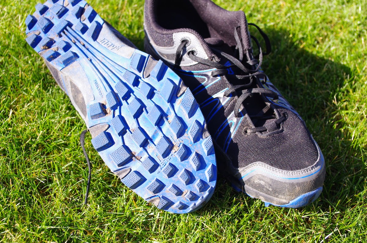

Another concern I had was water ingress. Footwear for backpacking is all about compromise between keeping water out and getting the shoe dry again afterwards. Even if you choose fully waterproof boots, water will always get in after a few days of hiking in wet weather — and when it does, those boots take ages to dry. I can attest to this from long experience!

If you choose lightweight, quick-drying footwear, you have to accept the fact that your feet will be wet some of the time. The Roclite 295 sits at this end of the scale. They make no attempt whatsoever to keep the water out; in fact, they welcome it in, but promise to dry just as quickly. I was interested to test this new approach.

The first twenty miles

The first step in the assessment of these shoes was to walk a few miles in them. Nothing too taxing at first: just five miles through the local fields. I decided to swap out the stock footbeds for my Superfeet Blues, which I have worn in all my hiking footwear since 2010.

I decided to stomp through as many ice-encrusted muddy puddles as possible.

Squelch
At first it was a shock! Water poured straight through the mesh uppers in a way that my Scarpa trail shoes had never allowed. However, within two minutes of walking through frozen puddles, my feet felt warm again and I could feel the water being pumped back out. I walked the five miles with wet feet but felt far more comfortable than I would have done wearing big boots in similar conditions.

When I got back home, the shoes were extremely muddy both inside and out. I cleaned them under the tap with an old toothbrush, reflecting that cleaning out the silt would be vital under similar conditions while backpacking, to avoid sediment rubbing against skin and causing blisters. However, in practice it's highly unlikely that you'll be forced to walk through such continuously oozy terrain for long distances; it's almost always possible to pick a different path. And, after all, wading through burns will do a lot of that washing-out for you.

I realised that the Superfeet were not the best insoles for these shoes. They're quite rigid, and didn't allow my feet to flex as much as they should have done. I decided it was better to use the minimalist footbeds that came with the Roclites.

Nevertheless, things were looking good. My next step was to take a slightly longer walk, this time in dry conditions. I selected a fifteen-mile hike through the Lincolnshire Wolds on a sunny day.

The hike was a pleasure. The shoes were continuously comfortable; it felt like hiking in slippers, and my feet never got too hot. Wearing boots in similar temperatures is always uncomfortable, because my feet tend to overheat and blister. It just wasn't a concern on that day. I didn't even feel any soreness under the balls of my feet. After fifteen miles, it felt like I had hiked about five in big boots.

How did the footbeds perform? Impressions were mixed. On the positive side, the thinner footbeds allowed more natural foot movement and were very comfortable. On the other hand, I don't think they fitted very well in the shoe, and both of them 'drifted' a little towards the heel — the left one by about an inch, leaving a gap under my toes. I had to stop twice to sort this out, which is unacceptable on a hike of such modest length.

The footbeds are clearly not the right size for the shoes. Rather than going back to the Superfeet, or looking for another pair of insoles to fit, I decided to adopt a more DIY solution. Seamgrip to the rescue! I don't want to stick them down permanently as this will make the shoes more difficult to dry out, but dry Seamgrip is very sticky so should provide enough grip.

A layer of Seamgrip on the bottom of the footbeds will stop
them drifting backwards in the shoe
Summary of first impressions

Overall, my first impressions of these shoes are extremely positive. They're lightweight, comfortable, and keep my feet cool and blister-free. They're grippy enough for mountain use and comfortable in the wettest, coldest conditions. My only ongoing concern is durability; will they last the two hundred miles of the Cape Wrath Trail? I don't know, but I'm beginning to think that durability is a sacrifice worth making for trail shoes this good.

I'll be sure to write up a more thorough review after I have tested these shoes to their limit on the long and rough miles of the Western Highlands.

Saturday, 12 April 2014

Returning to places of inspiration


This picture was taken exactly eleven years ago, on Saturday the 12th of April 2003. It's one of my favourite images from my first few years living on the Suffolk coast and also part of my collection of early digital images. In this blog post I'd like to ponder what it means to return to places that have significance for us, and how our own minds influence our perceived reality.

As a family, we first got a digital camera in 2002: a two megapixel beast that ran on 4xAA cells. Despite its woeful limitations by modern standards, this camera had a positive effect on both me and my brother James. Until then we had used traditional film SLRs: capable of taking brilliant photos, but cumbersome, limited, and relatively arcane to operate. James was always much better at the technical side of photography; I was only interested in recording moments in time.

And we recorded many of those moments. In 2002 and 2003 I hiked extensively in the Suffolk sandlings, always accompanied by the digital camera. I took thousands of photos, rapidly filling up the hard drive of our home computer.

It's no coincidence that I look back on 2002 - 2003 as landmark years for both my creativity and my personal development in general.

The link between countryside and creativity

Hiking — or simply being immersed, alone, in nature — has always fuelled my creativity, but in those early years I first consciously identified this phenomenon and learned to harness it.

I walked hundreds of miles through the Suffolk forests, discovering secret places and interesting viewpoints. I followed the coastal defences, sometimes walking 25 miles in a day along the coast. I saw many beautiful sunsets over the marshes. Often walking at night, I found that the thoughts and dreams that bubbled up from my unconscious mind were amplified by the solitude and the silence. During this period, my writing was prolific and I sometimes wrote 30,000 words a week, although I was also unskilled and started more projects than I finished.

The Staverton daffodil field

On the 12th of April 2003 I visited Staverton Thicks, a small wood of ancient oak pollards near Rendlesham. I had walked in Staverton before, but never all the way through to the other side and back through Tunstall Forest. This time I extended my walk.

I found a beautiful view, looking across a slope of daffodils to some birches. I took out my digital camera, recorded the image, and carried on with my walk without giving the scene a second glance.

Somehow, that image — which is a pleasing scene, but objectively nothing special — has taken on a deeper significance for me. That hike was one of many that year, but when I look back over the past decade that day is the one I remember above all others spent outside and alone in the Suffolk countryside. I couldn't tell you why, except that I associate it with all the positive things the outdoors has given me during my life.

But I have returned to that place many times since, and it has never been the same again.

Changing realities


This photo was taken on the 11th of October 2011. On that day I walked the route through Staverton more out of habit than anything else. I was living in Suffolk but my heart was elsewhere. I wanted to move to Lincolnshire and was looking for a job, but the process had dragged out far longer than I had expected and Suffolk was starting to feel like a prison.

I was writing intensively, but I felt at my least creative. I was editing The Only Genuine Jones and made no time for nurturing new ideas. Somehow my daily walks through the forest had lost their ability to inspire me to new creative efforts.

On that day, the daffodil field could not have looked more different. The trees had grown, overshadowing the path and enclosing the meadow on all sides. The sky was thick with rain and the atmosphere was oppressive, silent. No birds sang from the boughs of the ancient oaks.

I looked across the daffodil field and I saw no trace of my moment of inspiration from eight years before.

I wondered why places are never the same when we return. Does the wonder of discovery wear off? Do we walk the same well-worn paths to try and catch that spark we felt at first, only to reduce the power with each subsequent visit?

Perhaps it's significant that I no longer feel this way. When I return to places that have special meaning for me, I now feel the welcome embrace of old friends. When I go back to Great Langdale, or to Glencoe, or to my clearing amongst the birches in Tunstall Forest, I think back to past visits and I feel my batteries recharging. I come back from trips to the mountains brimming with fresh ideas and impatient to start writing something new.

Since those early years of hiking and digital photography I've learned that contrast is actually what feeds my creativity rather than nature alone. Too much of a good thing can dull my senses and take away the magic just as surely as too much time spent at the office.

The landscape changes but little; it is we who change.

Monday, 25 November 2013

How to turn an Android phone into a dedicated GPS device


This blog post is for my readers who enjoy the British mountains (that's the bulk of you!) Over the past few years I have enjoyed many trips into the hills with an Android smartphone, which is great if you want to use apps like ViewRanger but sometimes it can feel a bit too much like carrying the internet / work with you into the mountains. On my last trip it was all too easy to end up surfing the Web and wasting my battery during moments of downtime, and that isn't what hill trips are supposed to be about.

That got me thinking. How could I take advantage of genuinely useful apps without the distractions and disadvantages of having a smartphone with me as well?

The answer: take an old or second handset and convert it into a dedicated GPS device! It can of course still be used for emergency calls and texts if you choose, but my plan is to take out the SIM card and carry a cheap, light pay as you go handset for phone functions.

(Disclaimer: this post assumes the reader is proficient in mountain navigation and well aware of the advantages and disadvantages of using electronic devices for such tasks. This isn't the place for an epic UKC-style flamewar on the subject!)

The raw materials

I recently upgraded to a Galaxy Note 3, which left my Nexus 4 unused. I was tempted to sell it on eBay but the going rate isn't as much as I would have hoped, so I decided to keep it and re-purpose it. That's the great thing about smartphones: they're versatile little computers and can be put to any number of dedicated tasks.

Here's the list of ingredients:

  1. LG Nexus 4. Any relatively recent Android will do.
  2. An armoured case. Find one to fit your device.
  3. A small Ortlieb waterproof sleeve.
  4. A portable power pack plus USB cable. This pack is capable of charging the device several times from flat, and is sufficient for at least a week away from mains power.


The setup

The next task is to optimise the software to strip out all unnecessary functions and display a clear homescreen giving access to the most important features. Note that this is a simple procedure with no risk of damaging your device, but some familiarity with the Android system is recommended.

Step 1

Perform a factory reset on the device. Make sure you have retrieved any important data first.

Go into Settings -> Apps. Disable all of the apps except for critical ones like the Play Store, Settings, Clock, Downloads, and anything that the system won't let you disable. Don't disable Google Play Services or anything that isn't an obvious 'app', as these are often vital system services. It's perfectly safe to disable the Dialler, Contacts, Calendar etc. if you want to.

Step 2

Install the following apps:

  1. Nova Launcher. This is the custom launcher we will be using to create a clear and basic homescreen layout.
  2. Battery Widget Reborn. The best way of tracking battery drain.
  3. British Hills. This is a very useful offline database of all British mountains, including height and location data, plus the ability to check off the ones you have climbed. I use it to keep track of my Munro count.
  4. GPS Status. A precision GPS instrument giving you full sensor readouts and a night vision friendly display.
  5. Power Toggles. We will use this to create a settings shortcut bar.
  6. SkEye. An excellent stargazing app, great for those dark winter wild camps.
  7. TerraTime. This is the app you need for tracking sunrise and sunset times, moon phases, and other useful astronomical data.
  8. ViewRanger. This is my Ordnance Survey mapping and navigation instrument of choice, but there are many other suitable apps and personal preference will dictate which one you install. AVOID mapping apps which require a persistent data connection as these are USELESS in the mountains.


Step 3

Go back into the settings and turn everything off! Disable account auto-sync, background data, Bluetooth, and enable airplane mode. Turn WiFi back on as you will need it to download your maps into ViewRanger.

Step 4

Open Nova Launcher. Go into the settings and build a one-page homescreen, disable the dock and notification bar, and turn off icon labels. I've also increased the default size of homescreen icons. Set Nova Launcher as the default launcher.

Find a simple black wallpaper and apply it to both the desktop and the lock screen.

Step 5

Build a homescreen to your taste. Here's mine:


The widgets I have used are:

  1. Power Toggles, at the top. I customised the colours to blend in with the simple aesthetic and removed a few of the superfluous buttons. The only ones you really need are flashlight, GPS toggle, and brightness control.
  2. The standard digital clock widget.
  3. Battery Widget Reborn, which is a good way of keeping an eye on battery use.
  4. The TerraTime clock. Isn't it gorgeous? With this 24 hour clock you can see, at a glance, the sunrise and sunset times, moonrise and moonset, moon phase, and twilight hours: all very useful things to know on the hill, particularly for photographers!
  5. Shortcuts. The shortcuts I have chosen are for British Hills, SkEye, the app drawer, GPS Status, and Viewranger.
The result

The result is a simple Android machine optimised for outdoor tasks. All sources of unnecessary battery drain have been switched off or disabled, there is no Web access to distract you, and you have access to the information you need when in the mountains. The physical unit itself is clad in a rugged and waterproof shell (when inside its Ortlieb sleeve) and will have enough battery life for at least a week, thanks to the backup charger.

Has anyone else taken a second or old phone and turned it into an outdoor navigation gadget? I'd be interested to hear about your setup!